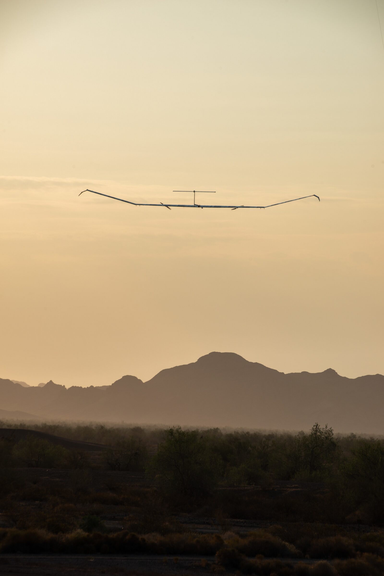
Launching the Zephyr requires five people running. They sprint together, holding a 25-meter solar glider by its wings until it lifts away—then they don't see it for months. The aircraft that departed U.S. Army Yuma Proving Ground on June 15, 2022, wouldn't touch ground again for 64 days, 17 hours, and 43 minutes. By the time it came down—not on a runway, but in an uninhabited area in western Arizona—it had crossed international airspace, flown over the Gulf of Mexico and South America, accumulated over 1,500 flight hours, and reset what anyone thought was achievable from a battery-powered drone.
The Zephyr S is Airbus's answer to a capability gap that satellites and conventional drones can't close on their own. It belongs to a class called High-Altitude Pseudo-Satellites—HAPS—aircraft that loiter in the stratosphere long enough, and with enough sensor persistence, to blur the line between platform and orbiting asset.
The Stratospheric Niche
HAPS operate above 60,000 feet—above commercial air traffic, above weather systems, and well below the geosynchronous belt at 22,000 miles. The stratosphere offers something neither regime can match: light winds, no convective turbulence, and enough solar flux at altitude to run a solar-electric aircraft indefinitely in principle. Surveillance satellites repeat their ground track on orbital mechanics, not operator demand. Tactical drones flying at 40,000 feet contend with weather, airspace deconfliction, and a logistics tail that makes multi-month persistence impossible. HAPS sidesteps all of that.
The Zephyr S achieves this with specs that are deliberately austere. Wingspan is 25 meters—roughly 82 feet—on a carbon fiber composite airframe. Maximum takeoff weight is 75 kg; empty weight is 25–30 kg. The entire upper wing surface is covered in solar cells feeding lithium-sulphur batteries that carry the aircraft through the stratospheric night without interruption. Cruise speed is 50–60 knots—slow by any measure, but sufficient to station-keep in the prevailing winds above 60,000 feet. The operating ceiling reaches 75,000 feet. Total power draw across propulsion, avionics, and payload is equivalent to a single commercial light bulb.
The payload envelope is tight by design. Early configurations accommodated roughly 5 kg of sensors; the commercial AALTO variant reportedly extends this to 45–50 kg. The hand-launch method—five crew, no runway, no ground support infrastructure beyond a clear stretch of flat terrain—reflects the same philosophy: maximum operational flexibility with minimal footprint.
From QinetiQ to Yuma, Through Wyndham
The Zephyr program originated inside QinetiQ, the British defense technology company spun out of the UK Defence Evaluation and Research Agency. EADS Astrium—now Airbus Defence and Space—acquired the program in March 2013. By then there was already a benchmark to beat: the Zephyr 7's 14 consecutive days aloft at Yuma Proving Ground in 2010, a world endurance record at the time.
The Zephyr 8 was engineered to surpass it systematically. It delivered a 30% weight reduction and 50% greater battery capacity versus the Zephyr 7. In February 2016, the UK Ministry of Defence contracted Airbus for two Zephyr 8 aircraft, with a third ordered later that year. The 2018 endurance attempt at Yuma produced 25 days, 23 hours, and 57 minutes of continuous flight—a new world record by a substantial margin.
Then came Wyndham Aerodrome in Western Australia. Two Zephyr 8 aircraft were lost there in successive years: one to severe weather in March 2019, a second to structural failure in September 2020. The losses set the program back heading into the 2022 U.S. Army campaign.
That campaign launched under Army Futures Command's Assured Positioning, Navigation and Timing/Space Cross-Functional Team. Zephyr 8, serial Z8-2, climbed out of YPG on June 15, 2022, carrying objectives built around energy storage characterization, battery longevity, solar panel efficiency, and station-keeping fidelity. It flew south into Mexico, east across the Gulf of Mexico, and south over South America—logging three firsts: first flight over water, first direct downlink while outside U.S. airspace, and longest duration (7 days) using satellite communications. YPG Test Officer Lori Slaughter confirmed the aircraft held an FAA certificate of authorization allowing it to fly above commercial traffic in national airspace.
"It has some design upgrades to make it a more capable system..." — Simon Taylor, Zephyr Program Head
The aircraft accumulated over 1,500 flight hours before an "unexpected termination" on August 18, 2022, brought Z8-2 down in an uninhabited area of western Arizona. No injuries, no damage to other aircraft. Army APNT/Space CFT Director Michael Monteleone stated: "That knowledge will allow us to continue to advance requirements for reliable, modernized stratospheric capabilities to our Soldiers." The cause of the terminal event has not been publicly detailed.
Sensor Stack and Coverage Geometry
The Zephyr's operational value flows from its payload suite, not its endurance alone. The Strat-Observer imagery system delivers NIIRS 6 imagery across approximately 1,000 km² of coverage—sufficient to resolve individual vehicles—relevant for ISR and for civilian applications including infrastructure monitoring and environmental assessment. AALTO's commercial EO product line, branded OPAZ (Optical Payloads for Airbus Zephyr), adds live 4K video to the same package.
The connectivity payload operates at a different scale: a single Zephyr at altitude covers approximately 7,500 km²—the equivalent of dozens of terrestrial towers—and transmits at 100 Mbps across a 1,000 km² radius.
AALTO and the Path to Commerce
In January 2023, Airbus Defence and Space spun the Zephyr commercial program into a separate entity: AALTO HAPS Ltd. The name compresses "Airbus, high ALTitude, zerO emissions." The rationale is clear from AALTO VP of Flight Operations Richard Tyler: "Airbus saw the business opportunity of stratospheric connectivity. But Airbus knows it isn't a comms company, so spinning AALTO out gave us the freedom to research that industry."
The commercial pitch centers on 5G direct-to-device connectivity for underserved regions—Africa, the Middle East, India, South America, Australia. Tyler put the target market plainly: "We can fill wide gaps in terrestrial infrastructure across the world for D2D connectivity...we're talking with the T-Mobiles and Deutsche Telekoms of the world."
AALTO's first Kenyan flight launched from AALTOPORT in Laikipia County on January 19, 2025, reaching 60,000 feet and sustaining continuous operations for more than 48 hours. Kenya—backed by the Kenya Space Agency and Civil Aviation Authority—is designated as AALTO's inaugural commercial operating location. UK CAA type certification remains pending. Former CEO Samer Halawi had set the target: "We are looking to finalise the type-approval process by the end of next year [2025]." AALTO's stated goal is full commercial operations by early 2026.
Why It Matters
The coverage gap between terrestrial cellular infrastructure and low-Earth-orbit satellite constellations is real and wide. LEO systems deliver global reach but at complexity and cost that doesn't scale efficiently for regional ISR or rapid disaster response. Towers don't follow floods, wildfires, or conflict boundaries. A single Zephyr at 70,000 feet—covering 7,500 km² with both radio and optical payloads—can be repositioned within its range on hours' notice and held on-station for what AALTO describes as up to 200 continuous days.
That 200-day ceiling represents a genuine operational shift: not a satellite on a fixed ground track, not a drone that requires a recovery team every few hours, but a platform that could spend six months loitering above a humanitarian crisis, a wildfire perimeter, or a remote maritime corridor without once requiring a runway. The 2022 mission cost Airbus an airframe. It returned 1,500 hours of stratospheric operational data. That is the trade the Army accepted—and the one AALTO is now attempting to make commercially viable.
Sources
- U.S. Army — Zephyr Flies at U.S. Army Yuma Proving Ground and Beyond
- Airbus — Zephyr HAPS Platform
- C4ISRNET — Airbus Wins UK Zephyr 8 Pseudo-Satellite Contract
- Breaking Defense — Army's Ultra-Endurance Zephyr Drone Comes Down After Unexpected Termination Over Arizona Desert
- Airforce Technology — Zephyr S High-Altitude Pseudo-Satellite (HAPS)
- Uncrewed Systems — Zephyr Solar-Powered UAV Development Profile
- Janes — AALTO Targets 2026 for Zephyr Full Operating Capability, Kenya as First Location
- Janes — AALTO Commences Kenya-Based Operations of Zephyr HAPS