Visible-light cameras are reflectance instruments. They capture photons bouncing off surfaces under illumination. Thermal cameras are something fundamentally different: they are radiometric detectors, measuring energy that objects emit on their own. Every material above absolute zero broadcasts infrared radiation continuously, with intensity and spectrum shaped by temperature and surface emissivity. As Aerial Accuracy's UAV Thermal Imaging Guide explains, every object above absolute zero emits infrared radiation — electromagnetic energy invisible to the human eye but detectable by specialized sensors.
A thermal payload needs no light source, produces no detectable emission of its own, and can resolve a human body in complete darkness as readily as at midday. Understanding what makes that possible — and where the physics stops cooperating — requires a look inside the sensor.
The Microbolometer: Resistance as a Thermometer
The dominant detector technology in UAV thermal payloads is the uncooled microbolometer, a focal-plane array built from either vanadium oxide (VOx) or amorphous silicon. Each pixel in the array is a tiny suspended element — thermally isolated from its neighbors — whose electrical resistance shifts in proportion to how much infrared energy warms it. Read out by processing electronics and converted to a 2D temperature map, those resistance changes become the image. No external illumination, no cryogenic coolant, no moving parts.
The design tradeoff that defines the category is the word "uncooled." LightPath Technologies notes that uncooled LWIR systems "eliminate the complexity, cost, and maintenance requirements of cryogenic coolers" — drawing only a few watts against the 20–50 watts consumed by a cooled mid-wave system. For a drone already managing battery capacity against payload weight, that difference is the reason uncooled sensors dominate the market. Module-level implementations reflect this directly: a 640×512 uncooled module can weigh just 20 grams, measure 21 mm × 21 mm, and run on less than 1.1 W.
LWIR vs. MWIR: Why Wavelength Matters for Drones
Infrared is not a monolithic band. Two sub-ranges dominate practical thermal imaging:
- Long-Wave Infrared (LWIR), 8–14 µm — Matches peak thermal emissions from objects in the everyday temperature range (roughly -20°C to 350°C). Penetrates smoke, dust, and light fog with minimal scattering. Uncooled microbolometer arrays work natively here.
- Mid-Wave Infrared (MWIR), 3–5 µm — Better suited to high-temperature targets above 300°C and to maritime or high-humidity operating environments where LWIR is attenuated. MWIR sensors typically require active cooling — adding weight, power draw, and cooldown time before first use.
For most UAV missions — SAR, building inspection, powerline survey, agriculture — LWIR wins on every practical axis. The exception is maritime operations and scenarios involving very high-temperature signatures, where MWIR's atmospheric transmission advantage is measurable. There is also a regulatory dimension: high-resolution cooled sensors (1024×768 and above) carry export restrictions that trace to their military origins, constraining what commercial operators can procure without licensing.
Resolution, Sensitivity, and What the Numbers Mean in the Field
Resolution in thermal imaging has two components that are often conflated: pixel count and thermal sensitivity.
Pixel count determines spatial resolution. The professional standard is 640×512 — 327,680 independent temperature measurements per frame. Consumer payloads start as low as 160×120; high-end sensors reach 1280×1024. Ground sample distance (GSD) ties pixel count to altitude: a 640×512 sensor at 100 feet AGL yields roughly 1.5–2 cm per pixel; a 320×256 sensor at the same altitude gives 4–5 cm per pixel. Aerial Accuracy identifies 640×512 as a common baseline for professional inspection work.
Thermal sensitivity is measured by NETD — Noise Equivalent Temperature Difference, the smallest temperature variation the sensor can resolve above its own noise floor. Professional UAV cameras achieve 30–50 mK NETD; consumer-grade sensors run 100–200 mK. High-end modules push to ≤25 mK, enabling discrimination of temperature differences as small as 0.05°C. Pixel pitch — the physical size of each detector element — is closely related: a 12 µm pitch (increasingly common in compact UAV modules) collects less energy per pixel than a 17 µm pitch, making the processing chain's noise management critical to achieving rated NETD.
The FLIR Duo Pro R HD illustrates where these parameters intersect in a production payload: uncooled VOx microbolometer, 7.5–13.5 µm spectral band, 640×512 or 336×256 resolution options, thermal sensitivity below 50 mK, 30 Hz frame rate, and an operational altitude ceiling of 38,000 feet.
Radiometric vs. Non-Radiometric: A Distinction That Controls What You Can Do With the Data
A non-radiometric thermal camera produces a relative image — lighter or darker pixels indicate hotter or cooler surfaces, but no calibrated temperature is associated with any pixel. For situational awareness, search and rescue, or basic navigation, that is often sufficient. For infrastructure inspection, compliance reporting, or any work requiring repeatability, it is not.
Radiometric cameras store a calibrated temperature value for every pixel in each frame, written to 14-bit RJPEG or radiometric TIFF formats. That means a 640×512 radiometric frame contains 327,680 independently queryable temperature measurements — numbers that can be compared across flights, used to generate delta-T anomaly maps, and cited against standards. Aerial Accuracy is direct about the distinction: radiometric thermal captures temperature information per pixel, making it the appropriate choice for serious inspection programs and repeatable reporting.
Accuracy tolerances differ by deployment. Ground-based radiometric cameras achieve ±2°C or 2% (whichever is greater). Drone-mounted cameras typically carry ±5°C or 5%, reflecting the additional error sources of altitude, atmospheric path length, and airframe-induced turbulence. Standards-governed work — roof moisture surveys per ASTM C1153, solar panel inspection per IEC TS 62446-3, electrical fault classification per NFPA 70B — must account for those tolerances explicitly.
Dual EO/IR Payloads and the Palette Problem
Thermal imagery alone is often ambiguous. A hot spot on a rooftop could be a moisture pocket, a failed HVAC unit, or reflected solar energy from an adjacent surface. Fusing thermal with simultaneous high-resolution visible imagery resolves that ambiguity operationally. The integration approach now standard across professional platforms is the dual EO/IR gimbal — UkrSpecSystems describes it simply as "two cameras in one — a conventional imaging system and an IR camera."
The DJI Zenmuse H20T takes this further: a 20MP zoom camera, 12MP wide camera, and 640×512 radiometric thermal sensor sharing a stabilized gimbal with an integrated 1200-meter laser rangefinder. The Matrice 300 RTK can carry three simultaneous payloads. The FLIR Duo Pro R HD pairs a 4K-capable visible imager (stills; 1080p video) with its 640×512 LWIR radiometric sensor. Teledyne FLIR's SIRAS (now discontinued) integrates a FLIR Boson thermal core with MSX (Multi-Spectral Dynamic Imaging) processing, which overlays visible-light edge detail onto thermal imagery in real time — sharpening spatial context without requiring post-processing fusion. The SIRAS achieved 31-minute flight time and IP54 weather resistance, positioning it as a field-deployable inspection platform rather than a laboratory instrument.
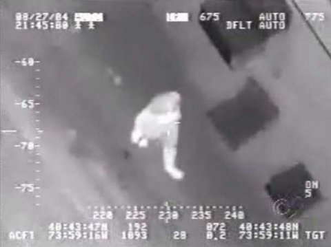
Color palettes are how thermal data becomes interpretable imagery. White Hot maps hotter pixels to lighter tones; Black Hot inverts that mapping. Rainbow distributes temperature across a full hue range, making gradient anomalies pop. The DJI Zenmuse H20T offers 12 palette options. Palette choice is operationally significant: SAR operators generally prefer White Hot because thermal signatures of human bodies read as bright targets against dark ground; electrical inspection favors Rainbow or Ironbow to highlight subtle delta-T gradients against a relatively uniform thermal background.
Where the Technology Actually Falls Short
The corollary to detecting emitted radiation is that thermal cameras measure surface temperature — only surface temperature. They cannot penetrate walls, roofs, or any solid opaque barrier to reveal interior structures. Subsurface anomalies (moisture trapped in a roof assembly, delamination in a turbine blade) are detectable only because they alter heat transfer through the material, producing a surface-temperature differential. Remove the thermal gradient — a uniformly warm building on a warm afternoon, for example — and the contrast disappears.
Material emissivity is a persistent source of measurement error. Polished metals, shiny plastics, and other low-emissivity surfaces reflect ambient thermal energy rather than emitting their own, making their apparent temperature in a thermal image unreliable. Wood, concrete, asphalt, and human skin (emissivity near 1.0 at normal body temperature) read cleanly. Sun glint and reflected thermal energy from nearby sources require emissivity compensation in post-processing or careful survey design.
Environmental constraints are real. LWIR is attenuated in high-humidity conditions (where MWIR has a distinct advantage). Professional roof moisture surveys per ASTM C1153 mandate a 48-hour dry window before the survey and acquisition 2–4 hours after sunset, with wind under 14 mph — protocols designed to ensure that the temperature differentials being measured are structural, not weather artifacts. Direct exposure of the sensor to intense energy sources — prolonged sun pointing, laser illumination — causes permanent damage with visible artifacts in all subsequent imagery.
Cost and certification add friction at the operational entry point. Professional UAV thermal systems carry significant capital cost, and FAA Part 107 certification is legally required for commercial UAV operations in the US. Meaningful data interpretation from radiometric imagery in inspection contexts typically requires Level I or Level II Thermography certification.
Against those constraints, the trajectory is toward miniaturization and broader deployment. The global thermal drone market projects 11.48% CAGR through 2035. Module-level 640×512 sensors now weigh 20 grams and consume under 1.1 W — hardware that would have demanded a multi-kilogram stabilized turret a decade ago. When CAL FIRE maps wildfire perimeters in real time, Southern California Edison surveys high-fire-risk powerlines preventively, and the Pasco County Sheriff's Office locates a burglary suspect hidden in dense woods, the common thread is a physics constraint now accessible at a price point that makes it routine.
Sources
- LightPath Technologies — LWIR Thermal Camera Guide for Industrial and Defense
- DJI Enterprise Insights — Thermal Drone Basics
- Aerial Accuracy — UAV Thermal Imaging Guide
- UkrSpecSystems — Thermal Drone Cameras and Infrared Imaging
- LightPath Technologies — LWIR Applications: Drones and Industrial Monitoring
- CMOS Camera Module — High-Sensitivity IR Module for Drone Thermal Payloads: Technical Analysis
- Drone U — Top Thermal Drone Applications 2025
- Teledyne FLIR — SIRAS Product Page