Every utility operator, pipeline company, and transportation agency in the United States runs the same arithmetic: thousands of miles of aging assets that must be visually certified on a schedule, using methods that are expensive, slow, and occasionally lethal. Helicopter patrols on transmission corridors, rope-access crews on wind turbine blades, scaffold rigs under highway bridges — these are the industry defaults, and their cost structures have barely changed in decades. Drones are now rewriting the numbers across every one of those verticals, and the shift is no longer marginal.
The Asset Classes and the Arithmetic
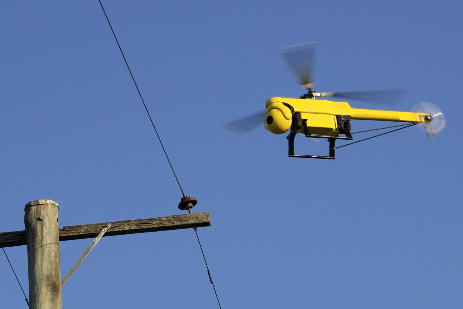
Transmission and distribution lines are the clearest case. Helicopter patrol runs $1,200 to $1,600 per mile; drone right-of-way surveys run $200 to $300 per mile, with detailed per-tower inspections at $500 to $2,000 per structure — a 50-to-75-percent reduction. The U.S. grid spans hundreds of thousands of miles of transmission infrastructure, most of it aging, all of it exposed to weather extremes. The savings compound quickly.
Bridge inspection tells a similar story. More than 46,000 U.S. bridges are structurally deficient according to the American Society of Civil Engineers' 2025 Infrastructure Report Card. State DOT programs have documented significant cost and time reductions when shifting to drone-assisted workflows. Caltrans has operated a drone inspection program since late 2019; Union Pacific deploys drones across its 32,000-mile network for bridges, culverts, and tunnels.
Pipeline economics are equally stark. Industry case studies indicate operators have reduced multi-day corridor inspections to a fraction of the original timeline, with scaffolding and access-crew costs eliminated at sites where aerial surveillance is sufficient for the inspection protocol. Pacific Gas and Electric's drone monitoring program reportedly identified 847 potential failure points in 2022 — a figure cited in industry reporting, though not independently verified from a primary PG&E source.
Wind turbines present a different problem: blades longer than a football field accumulate hundreds of millions of fatigue cycles over their lifetimes, with damage that starts as microscopic subsurface delamination invisible to telephoto cameras. The newer inspection platform generation pairs onboard cameras with phased-array ultrasonic sensors capable of detecting damage through the full blade thickness at any layer. Josh Paquette, a mechanical engineer in Sandia’s wind energy program, has said: “I can envision each wind plant having a drone or a fleet of drones that take off every day, fly around the wind turbines, do all of their inspections, and then come back and upload their data.”
Solar inspection is newer but the financial case is aggressive. Drone crews can inspect 50 to 100 megawatts per day; a 100 MW site takes two to four hours by air versus two to three weeks on foot. At least one leading AI analytics platform, Averroes AI, claims 98.5 percent defect detection accuracy for aerial solar inspection.
The Sensor Stack
Inspection programs worth taking seriously combine at least three sensor modalities. High-resolution RGB cameras — 20-plus megapixels with optical zoom — capture surface cracks, corrosion, insulator damage, and erosion at the detail level required for regulatory documentation. RTK/PPK positioning achieves one-to-three centimeter spatial accuracy, enabling dimensional measurements and change-detection between inspection cycles.
Radiometric thermal sensors detect hotspots caused by loose connections, failed components, or overloaded circuits. On solar panels, thermal imaging identifies cell hotspots, bypass diode failures, and string faults that are invisible under visible light. The IEC 62446-3 standard sets the minimum for warranty-valid solar inspections, specifying requirements for sensor resolution, radiometric accuracy, minimum solar irradiance, and wind conditions; the standard references a 600 W/m² irradiance floor, per industry implementation guides. Professional systems like the DJI Zenmuse H30T are built to meet these specifications.
LiDAR produces precise three-dimensional point clouds. For transmission lines, it measures exact conductor sag and vegetation-encroachment distances rather than estimating from overlapping photogrammetry. For bridges and civil structures, it creates dimensional models accurate enough to detect deflection and structural change across years of inspection cycles.
A fourth category — corona discharge detectors — visualizes partial electrical discharges around high-voltage insulators, a failure mode that neither RGB nor thermal cameras can capture. For high-voltage transmission work, this is not optional instrumentation.
The BVLOS Bottleneck — and the Framework Replacing It
All of the economics above assume a drone can fly a long linear corridor without stopping to relaunch at visual line-of-sight limits. That requires Beyond Visual Line of Sight authorization from the FAA, and until recently it meant a site-specific waiver requiring months of coordination with no repeatability at scale.
The FAA published its proposed Part 108 rulemaking on August 7, 2025, replacing the waiver system with a performance-based framework built around two standardized pathways — Operating Permits for lower-risk missions and Operating Certificates for complex work in populated areas — organized across five population-density categories. The provision most significant for infrastructure inspection is “Shielded Operations,” which allows flights within 50 feet of powerlines, railroad tracks, bridges, and pipelines without additional FAA authorization, subject to property-owner permission. A final rule is expected by spring 2026.
The 2024 FAA Reauthorization Act reinforced the push: it established the Drone Infrastructure Inspection Grant program — the first federal grant initiative helping local governments build drone inspection operations — alongside a $20 million drone workforce education program.
Operators accumulating individual approvals under the existing waiver system are effectively piloting what Part 108 will formalize. Dominion Energy received FAA authorization to remotely inspect power generation facilities across seven states using Skydio Dock systems with no on-site flight crew. New York Power Authority received its initial Blenheim-Gilboa hydroelectric plant BVLOS authorization in February 2023; in January 2026, the FAA approved an expansion allowing a single pilot to operate four drones simultaneously at the site. MFE Inspection Solutions obtained a nationwide BVLOS waiver in May 2025 to operate Skydio X10 drones remotely from its Houston office, shipping hardware to client sites and conducting inspections from thousands of miles away. BNSF Railway holds BVLOS authorization for docked Skydio operations over rural portions of its network.
“I can envision each wind plant having a drone or a fleet of drones that take off every day, fly around the wind turbines, do all of their inspections, and then come back and upload their data.” — Josh Paquette, mechanical engineer in Sandia National Laboratories’ wind energy program.
Dock-and-Recharge: The Autonomous End State
The logical conclusion of the regulatory momentum is the drone-in-a-box: a weatherproof docking station that automatically launches on a schedule, flies a programmed inspection route, lands, recharges, and uploads data — no human physically present. According to market research estimates, the global drone-in-a-box market is projected at approximately $3.38 billion by 2032, growing at roughly 13.7 percent annually.
Three platforms currently dominate commercial deployments. Percepto’s Air Max holds an FAA waiver for BVLOS operations up to 200 feet AGL and deploys AI-powered anomaly detection; the FAA has approved a configuration in which a single remote pilot can manage up to 30 drones simultaneously. The DJI Dock M30T charges from 10 to 90 percent in 25 minutes, carries IP55 weather certification for permanent outdoor installation, and pairs with DJI’s FlightHub 2 fleet management platform. Skydio’s Dock for X2 uses vision-based navigation for precision landing and runs a 45-minute recharge cycle; the newer Dock for X10 reduces that to approximately 35 minutes. Both are NDAA-compliant — the relevant threshold for U.S. federal infrastructure contracts concerned about CCP-linked component sourcing.
Physical testing, load-bearing verification, material sampling, and hands-on repair work on energized equipment remain human jobs. Confined-space inspections and close-contact work on structures where a drone can’t safely operate still belong to certified climbers and rope-access crews. The hybrid operational model — drones for frequent wide-area surveillance, humans for targeted follow-up — reflects the current reality at mature programs.
The safety case for the shift is not rhetorical. Falls are consistently the leading cause of fatalities in the U.S. construction sector, accounting for more than 1,000 deaths in a single recent year according to Bureau of Labor Statistics data. Every tower climb and scaffold deployment that a drone replaces eliminates that exposure entirely.
Sources
- Drone Launch Academy — Drone Power Line Inspection cost analysis
- Datumate — Drone Pipeline Inspection ROI analysis
- DroneLife — MFE Inspection Solutions nationwide BVLOS waiver
- UAV Coach — Drone Inspection sensor stack and corona discharge detectors
- Sandia National Laboratories — Flying Robots Replace Humans for Wind Blade Inspections (Josh Paquette quote, primary source)